The software needs the observer's position (longitude, latitude, altitude above sea level) and optionally accounts for atmospheric refraction.
Very precise algorithms are used for the computation of the sun position, but local atmospheric conditions can affect the actual values.
Exceptionally, the algorithm might not converge for very specific combinations of time and observer's location, but this limitation should not be problem for most of the users.
It can output either data tables or graphs.
>SunTimes.exe --day 12082007 --latitude 40 --longitude 3 --altitude 0.2 --verbose
Values for 12/08/2007 at 0.20 km height, 40° latitude and 3° longitude.

Morning Astronomical Twilight      : 03:10:08
Morning Nautical Twilight          : 03:48:45
Morning Civil Twilight             : 04:24:34

Sunrise                            : 04:57:08
Sun Transit                        : 11:53:06
Sunset                             : 18:49:03

Evening Civil Twilight             : 19:21:38
Evening Nautical Twilight          : 19:57:26
Evening Astronomical Twilight      : 20:36:04

Length Of Day:
- between sunrise and sunset       : 13:51:56
- between civil twilights          : 14:57:04
- between nautical twilights       : 16:08:41
- between astronomical twilights   : 17:25:56

Sun Elevations from observer's horizon, without atmospheric refraction:
Previous Minimum Sun Altitude  : -34.40°
Maximum Sun Altitude           : 65.45°
Next Minimum Sun Altitude      : -34.70°
>SunTimes.exe --start 01082007 --end 10082007 --latitude 40 --longitude 3 --altitude 0.2 --verbose
Values between 01/08/2007 and 10/08/2007 at 0.20 km height, 40° latitude and 3° longitude.
Interval is 1 day.

  Column 1  is the day (DD/MM/YYYY).
  Column 2  is the morning astronomical twilight time.
  Column 3  is the morning nautical twilight time.
  Column 4  is the morning civil twilight time.
  Column 5  is the sunrise time.
  Column 6  is the noon time.
  Column 7  is the sunset time.
  Column 8  is the evening civil twilight time.
  Column 9  is the evening nautical twilight time.
  Column 10 is the evening astronomical twilight time.
  Column 11 is the day length between sunrise and sunset.
  Column 12 is the day length between civil twilights.
  Column 13 is the day length between nautical twilights.
  Column 14 is the day length between astronomical twilights.
  Column 15 is the previous minimum sun altitude, in degrees.
  Column 16 is the maximum sun altitude, in degrees.
  Column 17 is the next minimum sun altitude, in degrees.

          	------ Morning ------	   	     	     	------ Evening ------	------- Length Of Day -------	------ Sun Altitudes -------
Day       	Astro	Nauti	Civil	Rise 	Noon 	Set  	Civil	Nauti	Astro	Day	Civil	Nauti	Astro	Prev Min	Max	Next Min
01 Aug 2007	02:54	03:36	04:13	04:47	11:54	19:02	19:36	20:13	20:55	14:15	15:23	16:38	18:01	-31.38		68.49	-31.63
02 Aug 2007	02:56	03:37	04:14	04:48	11:54	19:01	19:34	20:12	20:53	14:13	15:20	16:35	17:57	-31.63		68.24	-31.89
03 Aug 2007	02:57	03:38	04:15	04:49	11:54	18:60	19:33	20:11	20:51	14:11	15:18	16:33	17:54	-31.89		67.98	-32.15
04 Aug 2007	02:58	03:39	04:16	04:50	11:54	18:59	19:32	20:09	20:50	14:09	15:16	16:30	17:51	-32.15		67.72	-32.41
05 Aug 2007	02:60	03:40	04:17	04:51	11:54	18:58	19:31	20:08	20:48	14:07	15:14	16:27	17:48	-32.41		67.45	-32.68
06 Aug 2007	03:01	03:42	04:18	04:51	11:54	18:56	19:30	20:06	20:46	14:05	15:11	16:25	17:45	-32.68		67.18	-32.96
07 Aug 2007	03:03	03:43	04:19	04:52	11:54	18:55	19:28	20:05	20:45	14:03	15:09	16:22	17:42	-32.96		66.90	-33.24
08 Aug 2007	03:04	03:44	04:20	04:53	11:54	18:54	19:27	20:03	20:43	14:01	15:07	16:20	17:39	-33.24		66.62	-33.52
09 Aug 2007	03:06	03:45	04:21	04:54	11:54	18:53	19:26	20:02	20:41	13:59	15:04	16:17	17:36	-33.52		66.34	-33.81
10 Aug 2007	03:07	03:46	04:22	04:55	11:53	18:52	19:24	20:00	20:40	13:56	15:02	16:14	17:32	-33.81		66.05	-34.10
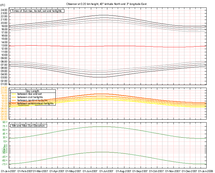
>SunTimes.exe --start 01012007 --end 31122007 --latitude 40 --longitude 3 --altitude 0.2 --graph 'test.png' --height 600

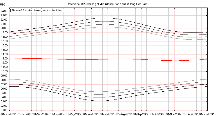
>SunTimes.exe --start 01012007 --end 31122007 --latitude 40 --longitude 3 --altitude 0.2 --graphtimes 'test.png'

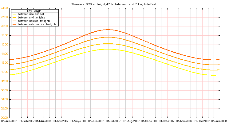
>SunTimes.exe --start 01012007 --end 31122007 --latitude 40 --longitude 3 --altitude 0.2 --graphdaylen 'test.png'

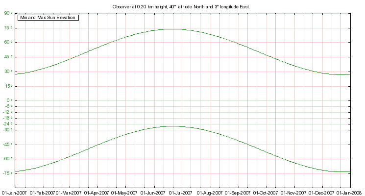
>SunTimes.exe --start 01012007 --end 31122007 --latitude 40 --longitude 3 --altitude 0.2 --graphalt 'test.png'

Current version is 1.1.1.0.
SunTimes binary and source can be downloaded through anonymous SVN at the following address:
https://anonsvn.loudet.org/SunTimes/tags/
SunTimes has been developped in C# under MonoDevelop 2.0. It can also be compiled under Visual Studio Express 2010.
It has been tested under Linux Ubuntu 9.10/Mono 2.4.2.3, and under Windows XP/.NET 2.0.
GDFONTPATH must be initialized to the relevant font path, for instance:
| --start--end --longitude --latitude | --locator --altitude --step [--refract|-r] [--verbose|-v] [--extended|-e] [--mysql|-m] [--gnuplot " "] [--graph null|" "] [--height ] [--width ] [--graphtimes null|" "] [--heighttimes ] [--widthtimes ] [--graphdaylen null|" "] [--heightdaylen ] [--widthdaylen ] [--graphalt null|" "] [--heightalt ] [--widthal ] Options: help Shows this message. day Date for which the values are calculated, for a single day calculation. Default is the current day. Format is DDMMYYYY (e.g. 12012006 for 12 January 2006). start Start day for several days calculations. Format is DDMMYYYY (e.g. 12012006 for 12 January 2006). end End day for several days calculations. Format is DDMMYYYY (e.g. 12012006 for 12 January 2006). longitude Value between -180 and 180 expressing the longitude of the location in degrees. String representations are accepted. Positive values in the eastern hemisphere. Default is 0. latitude Value between -90 and 90 expressing the latitude of the location in degrees. String representations are accepted. Positive values in the northern hemisphere. Default is 0. locator Maidenhead locator of the location. If set, latitude and longitude options must not be defined. altitude Real non negative value expressing the height of the observer for which the sun altitudes are calculated. Expressed in kilometers. Default is 0km (ground level). step Positive integer value representing the interval in days between two computations. Default is 1. refract Indicates if the atmospheric refraction is accounted for. verbose Shows legend. extended Shows full date and time (dd MMM YYYY HH:MM:SS). mysql Shows full date and time in mysql format (YYYYMMddHHMMSS). gnuplot Path to the gnuplot executable. If empty, default is: on Windows platforms [Program Files Directory]\gnuplot\bin\wgnuplot.exe. on Linux platforms /usr/bin/gnuplot. graph Path to the png file that will be created. set to null if the image is to be sent to stdout. Plot contains sunrise/transit/set/twilights times, day lengths and altitudes. height height of the png image, in pixels. Default is 400. width width of the png image, in pixels. Default is 745. graphtimes Path to the Times png file that will be created. set to null if the image is to be sent to stdout. Plot contains sunrise/transit/set/twilights times. heighttimes height of the Times png image, in pixels. Default is 400. widthtimes width of the Times png image, in pixels. Default is 745. graphdaylen Path to the Day Lengths png file that will be created. set to null if the image is to be sent to stdout. Plot contains day lengths. heightdaylen height of the Day Lengths png image, in pixels. Default is 400. widthdaylen width of the Day Lengths png image, in pixels. Default is 745. graphalt Path to the Altitudes png file that will be created. set to null if the image is to be sent to stdout. Plot contains sun altitudes. heightalt height of the Altitudes png image, in pixels. Default is 400. widthalt width of the Altitudes png image, in pixels. Default is 745. ]]>
|
SID monitoring station by Lionel LOUDET is licensed under a Creative Commons Attribution-NonCommercial-ShareAlike 3.0 Unported License. |
| Last Update: 04 Apr 2013 |
|
Apache/2.4.66 (Debian) |
|