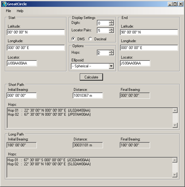
GreatCircle can be used using a graphical user interface or through command line.

The user needs to precise start and end points locations through either latitude/longitude or Maidenhead locator. After pressing the "Calculate" button, the short path and long path distances are shown as well as initial and final bearings. The calculation is done by default for a spherical Earth but a reference ellipsoid can be precised.
GreatCircle.exe.
GreatCircle.exe --longitude1 "0 0 0E" --latitude1 "10 0N" --longitude2 "120° 15' E" --latitude2 -25.3 --hops 2]]>The output of this command is: Help on the command line options are available by invoking:
>GreatCircle.exe --help
Current version is 1.0.0.0.
GreatCircle binary and source can be downloaded through anonymous SVN at the following address:
https://anonsvn.loudet.org/GreatCircle/tags/
GreatCircle has been developped in C# under Visual Studio Express 2008.
It has been tested under Linux Ubuntu 9.10/Mono 2.4.2.3, and under Windows XP/.NET 2.0.
--latitude1| --locator1 --longitude2 --latitude2 | --locator2 [--hops ] [--ellipsoid ] [--pairs ] [--precision ] [--decimal] Determines the distace between start and end points. Options: longitude1 String or real longitude value of the start point. Positive values in the eastern hemisphere. latitude1 String or real latitude value of the start point. Positive values in the northern hemisphere. locator1 Locator value of the start point. longitude2 String or real longitude value of the end point. Positive values in the eastern hemisphere. latitude2 String or real latitude value of the end point. Positive values in the northern hemisphere. locator2 Locator value of the end point. hops Number of hop positions to calculate, from 0 to 20. Default is 1. ellipsoid Reference ellipsoid to consider. Known ellipsoids are listed below. If not set, a spherical Earth is assumed and Haversine formulas are used. Precision on the distance is about 0.3%. If set, a spheroid Earth and Vincenty formulas are used. Precision on the distance is in the millimeter range pairs Number of locator pairs used to represent locators. From 1 to 6. Default is 3 (field+square+subsquare). precision Number of digits used to represent the values decimal parts From 0 to 15. Default is 2. decimal Displays latitude/longitude as decimal degrees, instead of DMS. GreatCircle --longitude1 --latitude1 | --locator1 --bearing --distance [--hops ] [--ellipsoid ] [--pairs ] [--precision ] [--decimal] Determines the end point at the specified distance and bearing from the start point. Options: longitude1 String or real longitude value of the start point. Positive values in the eastern hemisphere. latitude1 String or real latitude value of the start point. Positive values in the northern hemisphere. locator1 Locator value of the start point. bearing Initial bearing from start point to end point. In degrees. distance Distance in m from start point to end point. hops Number of hop positions to calculate, from 0 to 20. Default is 1. ellipsoid Reference ellipsoid to consider. Known ellipsoids are listed below. If not set, a spherical Earth is assumed and Haversine formulas are used. Precision on the distance is about 0.3%. If set, a spheroid Earth and Vincenty formulas are used. Precision on the distance is in the millimeter range pairs Number of locator pairs used to represent locators. From 1 to 6. Default is 3 (field+square+subsquare). precision Number of digits used to represent the values decimal parts From 0 to 15. Default is 2. decimal Displays latitude/longitude as decimal degrees, instead of DMS. KNOWN ELLIPSOIDS: : grs67: GRS 67 (IUGG 1967) grs75: GRS 75 (IUGG 1975) grs80: GRS 80 (IUGG 1980) merit: MERIT 1983 intl: Int'l 1924 newintl: New International (1967) iau76: IAU 1976 apl4.9: Appl. Physics. 1965 nwl9d: Naval Weapons Lab., 1965 clarke66: Clarke 1866 clarke80: Clarke 1880 clarke80mod: Clarke 1880 mod. nad27: NAD 27 nad83: NAD 83 timbalai: Timbalai maupertuis: Maupertuis 1738 plessis: Plessis 1817 (France) helmert: Helmert 1906 hayford: International 1909 (Hayford) lerch: Lerch 1979 krassovsky: Krassovsky 1940 kaula: Kaula 1961 australian: Australian National (1969) southamerican: South American (1969) cpm: Comm. des Poids et Mesures 1799 delambre: Delambre 1810 (Belgium) engelis: Engelis 1985 iers89: IERS (1989) iers03: IERS (2003) andrae: Andrae 1876 (Den., Iclnd.) wgs60: WGS 60 wgs66: WGS 66 wgs72: WGS 72 wgs84: WGS 84 airy: Airy (1830) modairy: Modified Airy hough: Hough (1956) seasia: Southeast Asia walbeck: Walbeck fischer60: Fisher (Mercury Datum) 1960 fischer60m: Modified Fisher 1960 fischer68: Fisher 1968 sphere: Normal Sphere (r=6370997) indonesian: Indonesian (1974) bessel: Bessel 1841 besselnamibia: Bessel 1841 (Namibia) everest30: Everest 1830 everest48: Everest 1948 everest56: Everest 1956 everest69: Everest 1969 everestpk: Everest (Pakistan) everestss: Everest (Sabah & Sarawak) everestmod: Modified Everest (Malaya) Revised Kertau sgs85: Soviet Geodetic System 85 ats77: ATS77 ]]>
|
SID monitoring station by Lionel LOUDET is licensed under a Creative Commons Attribution-NonCommercial-ShareAlike 3.0 Unported License. |
| Last Update: 10 Dec 2010 |
|
Apache/2.4.66 (Debian) |
|